
Toward Precision Citation
During the past few years, I have now sat through several presentations on precision/personalized medicine where the speakers have referred to a health information commons as being analagous to Google Maps. No fault of the presenters for they are citing a National Academies report titled Toward Precision Medicine: Building a Knowledge Network for Biomedical Research and a New Taxonomy of Disease (link is to a report brief) that contains the following diagram (the red box added by me to the left panel):
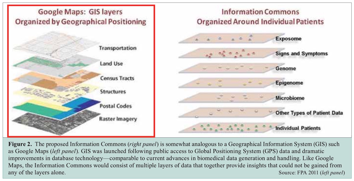
To be fair to the report writers, the figure caption says, “The proposed information commons is somewhat analagous to a Geographical Information System (GIS) such as Google Maps.”
Of course, that is enough for a slew of subsequent presenters to now refer to the new health info commons as being akin to Google Maps, and pointing to that map layers diagram. Besides the fact that one could argue (correctly) that Google Maps is not a GIS, what bothers me most is that the map layers diagram (the one on the left in the figure above) was really created in the mid-1980s, two decades before Google Maps came into existence. More on “Google Maps GIS” in a bit, but first, about that map layers diagram…
In 1988, a year after I started my Masters’s at the University of Wisconsin-Madison, I joined the Land Information and Computer Graphics Facility (LICGF) as research assistant. Stuck on the wall of my office was the following figure
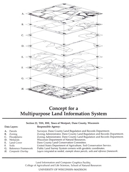
That diagram is from an article titled, Results of the Dane County Land Records Project, by Niemann1, Vonderohe and Moyer, published in the Proceedings of the American Society for Photogrammetry and Remote Sensing (ASPRS) 1987. In that article, the authors refer to the diagram with, “Second, a mathematical reference framework should provide the linkage between individual layers (Chrisman et aI., 1984; Chrisman and Niemann, 1985) (see Figure 1).”
Looking at the bibliography, here are those two citations:
Chrisman, N. R., D. F. Mezera, D. D. Moyer, B. J. Niemann, and A. P. Vonderohe, 1984. Modernization of Routine Land Records in Dane County, Wisconsin: Implications to Rural Landscape Assessment and Planning. URISA Prof. Paper 84-1. 44 p.
Chrisman, N. R., and B. J. Niemann, 1985. Alternative Routes to a Multipurpose Cadastre: Merging Institutional and Technical Reasoning. Proc. Allto-Carto 7, Washington, D.C, pp. 84-94.
Since I shared my office with my friend Jerome Gill Sullivan, I reached out to Jerry and asked him about the provenance of that diagram. Jerry said that actually he and Nick Chrisman made that diagram in ODYSSEY and published it in an article in the Proceedings of the American Congress on Surveying and Mapping (ACSM), 1984. (I am still trying to locate a physical or digital copy of that article, and will add the full citation to it soon as I get my hands on it.)
In Charting the Unknown: How computer mapping at Harvard became GIS, Nick Chrisman writes, “One December night, as Nick Chrisman, the designer of POLYVRT, and Denis White were waiting for batch editing jobs, they saw the solution to the Urban Atlas problem, a system of processors to manage large geographic files, or ODYSSEY.”
That was in 1975.
According to the Wikipedia’s entry on Global Positioning System (GPS), the GPS project was initiated in 1973 and became fully operational in 1995. The National Park Service (NPS) website states, “On June 26, 1993, however, the answer became as simple as the question. On that date, the U.S. Air Force launched the 24th Navstar satellite into orbit, completing a network of 24 satellites known as the Global Positioning System, or GPS.”
(Quoted from an articled titled “The Global Position System: The Role of Atomic Clocks”)
Back to the caption for the figure in the NAS report (see above), after wrongly referring to Google Maps as a GIS, the text goes on to say, “GIS was launched following public access to Global Positioning System (GPS) data and dramatic improvements in database technology.”
Oh man, what a trite and erroneous statement.
GIS was not launched, as that implies a single coming-out-party instance, but developed over a few decades. Additionally, software that could be referred to as GIS came into existence a couple of decades before GPS became publicly available.
So, why am I worked up about all this history? Well, for one, I have been a part of GIS history, even if in a small way. Second, I am deeply involved in a text-mining project that enables discovery of content as well as correct citation of it. And, for what its worth, I co-authored the chapter on data citation principles (Micah Altman, Daniel Cohen, and Puneet Kishor. 2013. Emerging Principles for Data Citation. In Yvonne M Socha (Ed.) Out of Cite, Out of Mind.. Data Science Journal 12: 1–76. doi:10.2481/dsj.OSOM13-043). Accurate citation is important, not just for proving due academic diligence, but also for giving credit where credit is due.
This also demonstrates how much mindshare Google occupies nowadays. This is certainly a point of concern as Google dives deep into our behavioral and health information not just through its ubiquitous data collection activities but also via its subsidiary ventures such as DeepMind that has been working closely with UK’s NHS. It is as if Google is sucking the oxygen out of the room and making us dizzy, lazy and inaccurate.
This brings to mind Isaac Newton’s famous quote, “If I have been lazy and inaccurate in my observations, it is because I have been standing on the shoulders of lazy and inaccurate giants.”
2